 Destinations
 Videos
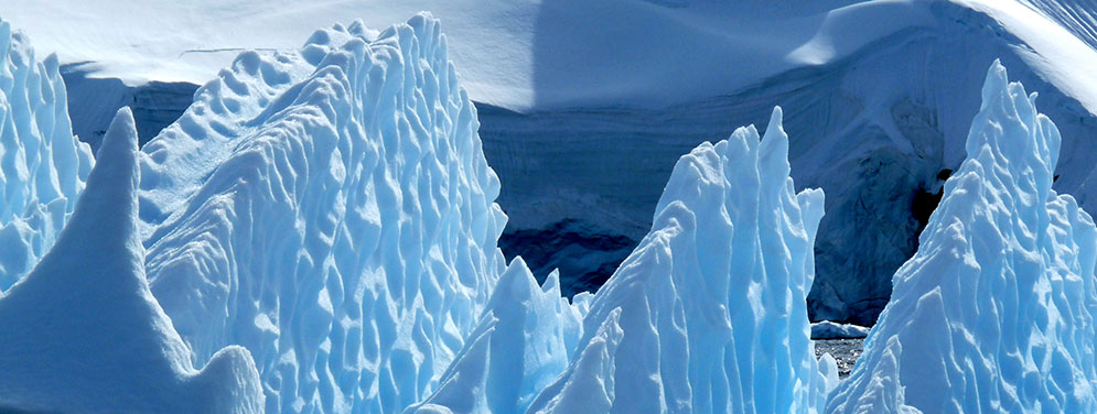
Antarctic travelogue
Lemaire channel to Petermann island
Day 4- Position: Lemaire channel
- Hour: 7:00pm
- Latitude: 64°54’S
- Longitude: 64°20’W
- Distance: 639Nm
- Air temperature: 2°C
- Water temperature: 2°C
 Great restful night during which our vessel finally stopped shaking in every possible way when entering Bismarck strait. I slowly wake up by 6h30 and suddenly realise that according to plan we should now have reached Antarctica peninsula. I jump of my bed (this is an image as I sleep in bunk beds), get dressed and rush to the upper bridge.
My first impression is to feel the cold. It might be because I just woke up but most certainly the temperature dropped during the night as we sailed closer to the continent Antarctica. The sky is blue, the ocean is flat and professor Multanovskiy always guided by cape petrels but also, and it's new, antarctic sterns. I can see the foothills of a mountain range marking the begining of Lemaire channel. While a thin layer of ice on the bridge obliges to walk with caution my sight is caught by a vertical spray of water about a hundred meters on the starboard side. I can't believe my eyes when I realise it's a whale. After a few seconds I count up to 8 whales around the ship as if to welcome us to Antarctica. One of them starts to wave at us with its pectoral fin, it's amazing! I'm sort of hypnotised by this breathtaking show all the more than we are only 5 to 10 people on the bridge because of the early hour. I don't feel the cold anymore. Little by little I realise that the famous Antarctica I've been dreaming of years after years is now before my gaping eyes, under a dazzling sun and guided by the most beautiful ambassadors, whales.
Our vessel now enters the narrow but gorgeous Lemaire channel overhung by high summits covered in snow and glaciers. 15 prior to our trip, the ice was so thick that the icebreaker struggled to sail. Today here and there mini icebergs float, sometimes forming icefields but nothing serious for Professor Multanovskiy. I go down to the lower bridge to get closer to the sea and hear the noise of the ice banging against the hull.
Alabatros and giant petrels accompany our vessel playing with updraughts in a seemingly affortless flight
I notice on the snowy shores long lanes looking like ploughs. Steven, the natural scientist of the expedition explains these are called penguins highways: Day by day, penguins use the same path to go to sea and back to their nest, digging naturally deep lanes in the snow creating many crossing regulated by a local traffic law! After a while Gentoo penguins are located in the water or on icebergs.
Professor Multanovskiy continues its path through Lemaire channel where the bright sun shed a beautiful light on the surrounding mountain ranges, glaciers and icebergs. Across Petermann island, the vessel anchors while we get dressed with our waterproof clothing with a view to boarding the zodiacs...
[Read more of day 4] Petermann and Argentine islands